Casual Beach Snaps Turn Into Critical Climate Change Data for Coasts
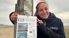
Everyday photographs captured by the public at beaches are being reutilized as a crucial resource for scientific inquiry into the impacts of climate change on coastal regions. This pioneering methodology harnesses broad public participation for vital environmental research, transforming informal holiday pictures into essential data points.
Coastal environments across the globe are confronting escalating dangers from climate change, including erosion, rising sea levels, and altered ecosystems. Gaining insight into the precise processes and pace of these transformations is essential for developing successful conservation and management plans, necessitating continuous and widespread observation.
While tracking coastal alterations traditionally involved costly and intensive field surveys, satellite images, and specialized gear, researchers are now accessing the vast repository of user-contributed material – specifically, photographs shared by those visiting beaches – to build enduring visual histories of these ever-changing settings.
Taken sometimes decades apart from identical spots, these pictures furnish priceless visual proof of alterations like shoreline movements, dune deterioration, shifts in plant life, and the aftermath of severe weather incidents. They furnish a historical view of coastal development that is challenging to acquire through established methods.
This project showcases the expanding domain of citizen science, where individuals from the public actively participate in scientific endeavors. By harnessing the immense quantity and broad geographical reach of personal photos, investigators are able to collect data on a scale previously unimaginable, vastly exceeding what conventional scientific missions could accomplish within an equivalent period.
The understandings gleaned from this photographic information are vital. They contribute to refining climate models, pinpointing especially susceptible zones, and guiding local and national strategies concerning coastal defense, infrastructure development, and biodiversity preservation initiatives, thereby facilitating more forward-looking and data-supported choices.
With the continued spread of digital photography and the advancement of image-sharing platforms, the capacity for this kind of citizen-driven data gathering to grow is enormous. This evolving reservoir of visual intelligence is set to become an ever more critical instrument in humanity's quest to grasp and adjust to the shifting effects of a changing climate on our invaluable coastal regions.


Comments (0)
Be the first to comment.
Join the discussion